 The Rogue River area is steeped in interesting history and lore. Even how the region acquired its name, the Rogue, dates back to the earliest of Oregon inhabitants. History books tell us that the native Indians were a particularly troublesome lot to the French who were the first white men to explore this territory, so they dubbed them “Les Coquins,” or “the Rogues.” The French then extended the name to the region and then next to the river because it was such an integral part of the lives of the Indians, providing transportation, food and other necessities of life.
Over the years, the Rogue River and its people, continued to build a colorful history. A history filled with tales of gold, fish, adventurers, floods, dreams, dams, and much more. The one constant that wound and wrapped itself through every historical twist and turn was the river, the mighty Rogue.
Tucked away in Crater Lake National Park, tiny streams bubble up from beneath moss-covered rocks. It is here that the Rogue River is born…quietly bubbling up out of these tiny streams. From this minute beginning, the incredible Rogue River carves its way through 215 miles of rock and stone before it spills into the Pacific Ocean. These Rogue River headwater streams are known as the Boundary Springs and-along with Crater Lake-give the mighty Rogue River its life.
To understand some of the places and the history that grew up around the Rogue River, you should take a minute and review with us the three distinct areas of the River: the Upper Rogue, the Middle Rogue, and the Lower Rogue.
UPPER ROGUE: (Boundary Springs/Crater Lake to the town of Prospect)
About 40 river miles
This section of the Rogue is paralleled by a major highway and tourist route from Crater Lake national park. The river cuts through volcanic rock, drifts past alder-lined banks and Douglas fir and pine-oak forests, riffles over gravel beds and bedrock and slips under bridges and behind new homes, weaving its path through the heart of Jackson County.
The Upper Rogue is fed by snowmelt and springs originating on the peaks of the Cascade Range, including the slopes of Mt. Mazama-the volcanic caldera that contains Crater Lake. Along the uppermost portion of the Upper Rogue, the river is narrow and shallow but very swift. Numerous moss-draped snags of lodge pole pines and other trees that have fallen across the river slow its pace only a little. The river has, for a two-mile stretch, carved more than 200′ down into the Mazama pumice (which was deposited about 8,000 years ago during the explosion that created Crater Lake.) This sheer, white-walled canyon, with the whitewater river glinting in the sunlight far below, is a favorite sight for travelers along Highway 230.
In addition to its clear, clean water and scenic beauty, the Upper Rogue is notable for its history. Parallel to Highway 62 between Farewell Bend and Natural Bridge, it passes through part of the Union Creek Historic District, listed on the National Register of Historic Places for the rustic 1920s – 30s buildings at Union Creek Resort and the nearby former ranger station. At Union Creek Wayside, a traveler’s comfort station along Highway 62, an interpretive kiosk tells the history of Union Creek. (The community of Union Creek was named after Union Peak in Crater Lake National Park. Union Peak got its name in 1862 when it was christened by a couple of prospectors, Chauncy Nye and Hiram G. Abbott. The prospectors were mindful of the country’s Civil War, which had begun the year before, when they named it. The name stuck, even though there was a large population of people with pro-Confederate feelings in Jackson County.)
Following along the banks of the Upper Rogue is the Upper Rogue River Trail…a designated National Recreation Trail. Because of various road crossings, much of this hiker-only trail is easily traveled for short segments at a time.
The Upper Rogue is considered extremely hazardous for whitewater boating due to its gorges, chutes, and many obstructions-ranging from “sweeper” logs across the river to the underground section at Natural Bridge.
Campgrounds located in this section of the Rogue include: Farewell Bend, Wayside, Abbott Creek/Woodruff Bridge, Mill Creek and River Bridge campgrounds.
MIDDLE ROGUE: (Prospect to Applegate)
The Rogue River is frequently more than 150 feet wide in this section. It flows through an ancient valley, formed about 1 million years ago when Western Oregon slowly uplifted to form the Pacific Coast Range.
This part of the river is especially noted for its runs of large, feisty spring Chinook, followed by the famed summer Steelhead. Avid fisherman say it offers the finest Steelhead fly-fishing on the river.
Long before the arrival of fur trappers, traders, miners and other settlers, several thousand natives lived in this valley. Collectively referred to as the Rogue River tribe, these natives were actually members of the Takelma, Shasta, Dakubetede or Applegate River tribes.
The arrival of white settlers to this area was triggered by the Donation Land Act, which awarded 640 acres of land to each couple who became settlers, and by the discovery of gold along the Rogue River in 1851.
Like the native tribes and the first white settlers, the people who live here today rely on the strength and endurance of the Rogue for recreation, livelihood, beauty, and inspiration.
The area offers abundant recreational choices. You can hire a fishing guide for a day and “hook a big one.” You can take a full-day or half-day float trip down rapids with such imposing names as: Rattlesnake Falls, Nugget Falls, and Powerhouse rapids. You can ride the wild twists and turns of the jet boats. You might even horseback ride along the trails that follow the Rogue’s meandering journey. Or, enjoy the unique and wonderful Oregon wines and vineyards that have been planted and tended along the Rogue’s fertile shorelines.
The small towns of Shady Cove (In the 1860s, pioneer Ham Watkins, who ran a ferry across the Rogue River before a bridge was built in the 1920s, was probably the first settler on a small, shady spot on the river just east of the town that later took its name), Gold Hill (is the site of an early gold discovery in Southern Oregon. The original Gold Hill settlement was on the south bank of the Rogue River, opposite the present city), Rogue River and the larger city of Grants Pass (As the story goes, news of the capture of Vicksburg during the Civil War by Union forces under General Ulysses Grant reached Southern Oregon, where workers were improving a road north of where the town is now. They celebrated by calling it Grants Pass.) are located along this section of the river.
The city of Gold Hill stakes its claim in this section of the Rogue River and has a deep history in…surprise…gold! The city traces its roots back to the discovery of a large gold nugget in 1852 at Big Bar on the Rogue River. More than 200 miners came running in response to the news, but their initial efforts were largely an exercise in futility. It took them years to develop lucrative gold mines. According to one report, since the first discovery of gold in the area, the mines of Jackson and Josephine Counties have yielded as much as $30 million worth of the precious metal. In 1860, the first quartz mine in the county was established in Gold Hill, and limestone, marl, and magnetic iron were also discovered in abundance.
Noted geographic formations known as Upper Table Rock and Lower Table Rock are also located in this section of the Rogue River. Upper and Lower Table Rocks, the landmark mesas that stand nearly 1,000 feet above the nearby Rogue River, were the site of the Rogue Indian Wars. The Table Rocks loom like watchtowers over the valley, and the 300 Indians who once lived in their shadows used to scale them to keep track of the incoming gold seekers and settlers who arrived to homestead on their land. Today, visitors can hike to the top of these rocks and enjoy panoramic, picturesque vistas of the Rogue River Valley.
LOWER ROGUE: Wild & Scenic Section
The Rogue was one of the original eight rivers included in the Wild & Scenic Rivers Act of 1968. This section begins 7 miles east of Grants Pass and ends 11 miles east of Gold Beach and stretches for 84 total miles. The Rogue River is one of the most desirable Pacific NW vacations because of its incredible beauty and wildlife-and because it has been protected for decades by the aforementioned “Wild and Scenic” act.
Steelhead and salmon fishing, challenging whitewater, and extraordinary wildlife viewing opportunities have made the Rogue a national treasure. Black bear, river otter, black-tail deer, bald eagles, osprey, Chinook salmon, great blue heron, and Canada geese are common wildlife seen along the Rogue River. Popular activities include: whitewater rafting, fishing, jet boat tours, scenic driving, hiking, camping, picnicking, and sunbathing.
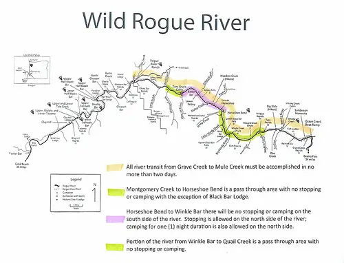
The Wild Section of the Lower Rogue River is one of the most popular whitewater runs in the world. Its popularity is heightened by a steady water level due to dams upstream, hot, sunny summer weather, and exciting whitewater rapids through lush forests and steep canyons. White Water Warehouse is one of a few BLM and USFS permittees authorized to run this incredible wild section from Graves Creek to Foster Bar. If you would like to join their professional team of rafting guides, check out White Water Warehouse’s schedule for dates and rates.
The Rogue’s lower section of river is steeped in history and heros as well. This is a place where cell phones won’t work. You won’t see much development. A few lodges and the wildlife will be your only companions. Those who choose to float this magnificent section of the river are privileged since the Bureau of Land Management, one of the governing bodies of the Rogue River, allows only 120 guests per day on this protected section of river. If you get the chance to raft, kayak or hike the lower Rogue, you will see rocks formed 190 million years ago as part of the Klamath Mountains. You’ll see “younger” rocks formed in the Coast Range around 50 million years ago. At the most infamous rapid on the river, known as Blossom Bar, big boulders strewn across the middle of the river are “younger” yet probably brought down Blossom Creek in a mudslide during the past 150 years to rest on 190-million-year-old bedrock, geologists say.
The highest the Rogue River has ever been measured at Agness is 68.03 feet on December 23, 1964. Flood stage is 17 feet. During the 1964 flood, the Rogue River poured out at 290,000 cubic feet per second, or 2,171,810 gallons flowing by every second. The second-highest level was 48.54 feet recorded on January 16, 1974.
Hiking and floating the wild section of the river is permit only from May 15 through October 15 each year. The Bureau of Land Management and the US Forest Service are the two governing bodies that protect and regulate this section of the river.
The Rogue is one of the only “wild and scenic” designated rivers to also accommodate rustic, riverside lodges that welcome guests from early May through late November each year. Current Rogue River lodges include Black Bar, Marial, Halfmoon Bar, Paradise, Clayhill, and Illahe, Singing Springs, and Lucas Lodge.
Early Rogue pioneers included the famous Glen Wooldridge who many claim was the first person to navigate the Rogue in a wooden dory. His knowledge of running the Rogue’s whitewater rapids and fishing became the stuff of legends. He mentored many a fishing guide on the technicalities of the river.
Another famous Rogue homesteader was noted author Zane Grey. Known for his western novels and fishing novels set on the Rogue River, Grey built a cabin on the Rogue which can still be seen and visited today.
The lower Rogue’s beautiful whitewater is enhanced with names such as: Grave Creek, Wildcat, Horseshoe Bend, Mule Creek Canyon, Coffeepot, Blossom Bar, and Rainie Falls. The river’s rapids range from Class I through Class V…but most of the water is very family friendly-with guests enjoying the warm water and mellow stretches.
The main activities that guests enjoy on the Rogue River are rafting, kayaking, fishing, and hiking throughout the summer months.