| Section of river: | Firth River, Yukon |
| Difficulty: | Class 3 |
| Length: | 100 miles/ 9 days; 162 KM |
| Season: | June – August |
| Best rapids: | Sheep Slot, Caribou Fence |
 The Firth River flows northeast from Alaska through the British Mountains and coastal plain of the Northern Yukon and drains into the Beaufort Sea southwest of Herschel Island.
The entire watershed of the Firth is contained in the boundaries of the Arctic National Wildlife Refuge in Alaska and Ivvavik National Park in Canada. Together these organizations protect this wilderness and ensure the long-term preservation of the natural and cultural resources of the region.
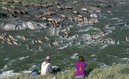
 The Firth River is likely the oldest river in Canada and definitely one of the wildest. Bisecting this incredible national park, it is the summer home for 150,000 caribou of the west Porcupine herd.
An expedition down the Firth River offers a spectacular, educational and challenging Arctic wilderness adventure. The opportunity to view wildlife, as well as experience the natural and cultural features of the region add to the uniqueness and excitement of the trip.
 The Firth lies in an extremely remote and isolated region. To ensure the park remains wild there are no roads or even trails. Air access is controlled and regulated by permits. Fewer than 200 people visit the park each year, leaving the land almost entirely to its natural inhabitants. There are no settlements in the park. However, traditional subsistence hunting is still carried out seasonally by local native peoples. The interior of the park is dominated by the British Mountains, which rise to over 1800 meters along the Yukon-Alaska boundary. Since the National Geographic Society first descended the Firth in 1981, very little visitation has occurred.
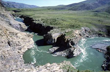
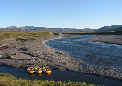
The Firth is a relatively small volume river wending its way gracefully towards the coast. The river features many lively Class III and small Class IV rapids with technical obstacles such as ledges and chutes. Utilizing the rafts as vehicles of access allows boaters to cover reasonable ground by river and reach the best hiking regions for base camps.
Camps are plentiful in most of the river sections and range from gravel bars, grassy meadows to sandy beaches. The Firth corridor features barren mountain slopes and ridges that are accessible from riverside camps. Easily gained ridges afford excellent views of the river valley and British Mountains. The higher ridges and those further downstream offer views of the Beaufort coast and Herschel Island. At this latitude, above the Arctic Circle, the sun does not set in the summer months and allows us endless opportunities for hikes, photography and fishing.